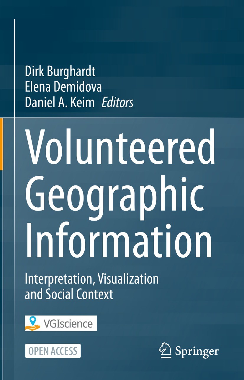
We are happy to announce the release of our book!
This open access book includes methods for retrieval, semantic representation, and analysis of Volunteered Geographic Information (VGI), geovisualization and user interactions related to VGI, and discusses selected topics in active participation, social context, and privacy awareness. It presents the results of the DFG-funded priority program “VGI: Interpretation, Visualization, and Social Computing” (2016-2023).
The book includes three parts representing the principal research pillars within the program. Part I “Representation and Analysis of VGI” discusses recent approaches to enhance the representation and analysis of VGI. It includes semantic representation of VGI data in knowledge graphs; machine-learning approaches to VGI mining, completion, and enrichment as well as to the improvement of data quality and fitness for purpose. Part II “Geovisualization and User Interactions related to VGI” book explores geovisualizations and user interactions supporting the analysis and presentation of VGI data. When designing these visualizations and user interactions, the specific properties of VGI data, the knowledge and abilities of different target users, and technical viability of solutions need to be considered. Part III “Active Participation, Social Context and Privacy Awareness” of the book addresses the human impact associated with VGI. It includes chapters on the use of wearable sensors worn by volunteers to record their exposure to environmental stressors on their daily journeys, on the collective behavior of people using location-based social media and movement data from football matches, and on the motivation of volunteers who provide important support in information gathering, filtering and analysis of social media in disaster situations.
The book is of interest to researchers and advanced professionals in geoinformation, cartography, visual analytics, data science and machine learning. It is published at Springer Professional under Creative Commons Attribution 4.0 International License (CC BY 4.0).
Title:
  - Volunteered Geographic Information

Editors:
  - Dirk Burghardt
  - Elena Demidova
  - Daniel A. Keim

Copyright Year:
  - 2024

Publisher:
  - Springer Nature Switzerland

Electronic ISBN:
  - 978-3-031-35374-1

Print ISBN:
  - 978-3-031-35373-4

DOI:
  - https://doi.org/10.1007/978-3-031-35374-1
The release is accompanied by a video podcast featuring Prof. Dr. Sven Lautenbach and Moritz Schott. In the video, the researchers provide an introduction to OSM, OSM data quality and the OEV.

The OSM Element Vectorisation Tool (OEV) enables high resolution data insights into the OSM database. Through researchers, corporations, and (mainly) private users and contributors, the OSM ecosystem has grown to encompass a massive set of tools and services that accompany the data and maps themselves. However, many of these tools and services are either general purpose tools to “do something with the data” or specialized tools to “find out a specific thing” rather than a combination of the two. For example, is-osm-uptodate is a fantastic tool to answer the exact question in its name in a data-driven manner. Alternatively, scientific studies often concentrate on a specific region, as seen in comparing OSM to official data in Teheran (Iran).
The tool sets out to overcome these limitations by combining and providing what has so far been divided and conquered. Specifically, the tool creates a multi-faceted data view that is neither limited to a certain region nor to a specific topic. The goal is to enable data enthusiasts, data analysts and machine learners to visualize a multi-dimensional view of the data without the setup of requisite tools, data and services.

OEV computes more than 37 data dimensions and is based on more than 16 scientific studies, with more dimensions and studies planned for future incorporation. Since the presentation of the tool at the FOSS4G conference 2022 in Florence, additional data insights have been added including user specialization and diversity. These two aspects provide information about the professionalism of the objects editors by calculating how experienced the users are with edits on objects of this type (e.g., land-use, buildings or shops). Moreover, the tool has been made more robust and versatile and is now ready for a first official release to the public.
The full list of indicators and their documentation is available in the tools repository. But you can also quickly dive into its usage on our intuitive frontend which provides some precomputed examples.
While we use the tool in our current research and have shown its practicality in the article “OpenStreetMap Element Vectorization- A Tool for High Resolution Data Insights and Its Usability in the Land-Use Land-Cover Domain” published in The International Archives of the Photogrammetry, Remote Sensing and Spatial Information Sciences, we have added additional examples in a dedicated repository: OEV Examples.
Related work
Bruckner, J., Schott, M., Zipf, A., Lautenbach, S., 2021. Assessing shop completeness in OpenStreetMap for two federal states in Germany. AGILE: GIScience Series, 2, 20.
Herfort, B., Lautenbach, S., de Albuquerque, J. P., Anderson, J., Zipf, A., 2021. The evolution of humanitarian mapping within the OpenStreetMap community. Scientific Reports, 11(1), 1–15.
Jokar Arsanjani, J., Mooney, P., Zipf, A., Schauss, A., 2015. Quality assessment of the contributed land use information from openstreetmap versus authoritative datasets. J. Jokar Arsanjani, A. Zipf, P. Mooney, M. Helbich (eds), OpenStreetMap in GIScience: Experiences, Research, and Applications, Springer International Publishing, Cham, 37–58.
Neis, P., Zielstra, D., Zipf, A., 2013. Comparison of Volunteered Geographic Information Data Contributions and Community Development for Selected World Regions. Future Internet, 5(2), 282–300.
Neis, P., Zipf, A., 2012. Analyzing the Contributor Activity of a Volunteered Geographic Information Project — The Case of OpenStreetMap. ISPRS International Journal of GeoInformation, 1(2), 146–165.
Raifer, M., Troilo, R., Kowatsch, F., Auer, M., Loos, L., Marx, S., Przybill, K., Fendrich, S., Mocnik, F.-B., Zipf, A., 2019. OSHDB: a framework for spatio-temporal analysis of OpenStreetMap history data. Open Geospatial Data, Software and Standards, 4(1), 1–12.
Schott, M., Grinberger, A. Y., Lautenbach, S., Zipf, A., 2021. The Impact of Community Happenings in OpenStreetMap—Establishing a Framework for Online Community Member Activity Analyses. ISPRS International Journal of GeoInformation, 10(3), 164.
Schott, M., Zell, A., Lautenbach, S., Zipf, A., Demir, B., 2022. LULC multi-tags based on OSM, Version 0.1. https://gitlab.gistools.geog.uni-heidelberg.de/giscience/idealvgi/osm-multitag.
Schultz, M., Voss, J., Auer, M., Carter, S., Zipf, A., 2017. Open land cover from OpenStreetMap and remote sensing. International Journal of Applied Earth Observation and Geoinformation, 63, 206-213.
Zielstra, D., Zipf, A., 2010. A comparative study of proprietary geodata and volunteered geographic information for Germany. 13th AGILE international conference on geographic information science, 2010, 1–15.
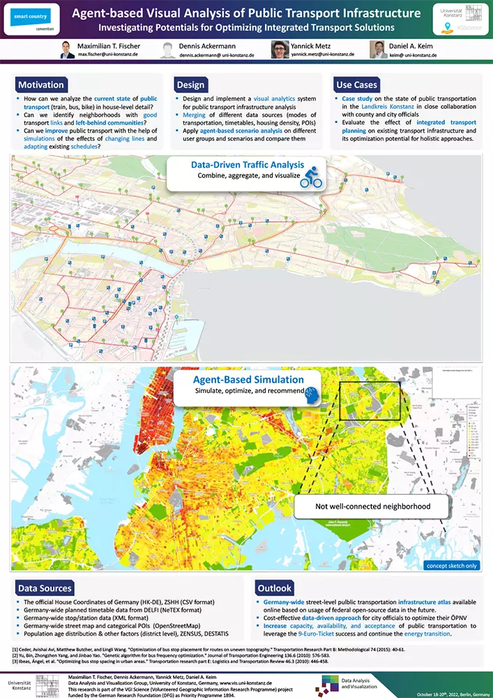
]]>The following topics were presented and discussed over the two days:
- Review of 6 years of VGIscience, Prof. Burghardt (slides)
- Keynote Prof. Werner Kuhn: “Interdisciplinarity quo vadis: What can we learn from the VGI experience?”
- Presentation of the research results of the individual projects
- Selected SPP collaboration projects of the Young Research Groups
- Panel future of VGI research
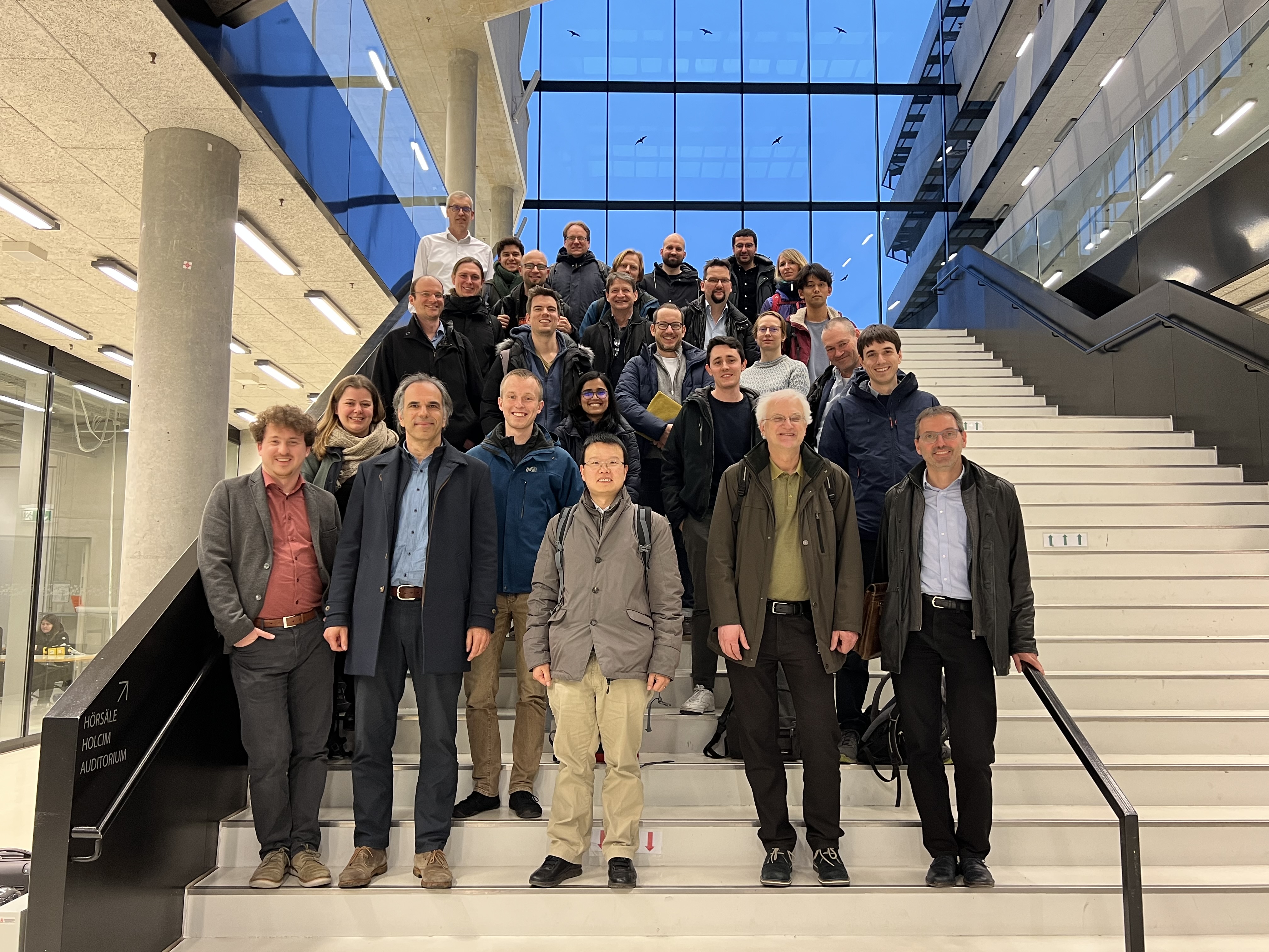 The photo shows the participants of the VGIscience final colloquium in HafenCity University Hamburg.
The film features three of the researchers from the Institute of Cartography at the TU Dresden, Alexander Dunkel, Eva Hauthal and Marc Löchner. Alex is a postdoc with a background in landscape and urban planning. The research of Eva, also a postdoc, aims at studying the emotions and sentiments of social media users. Marc is a PhD student and dedicates his doctorate to the privacy implications of evaluating social media data.
As social media data reflects real-life information from people’s daily activities, it has become a popular source of information in research. This research usually does not focus on questions of (e.g.) advertising or user profiling, but on fundamental questions of society, particularly those that are connected with the increasing use of geo-social media, information spread, and associated environmental questions. During the two VGIscience phases, privacy became an increasingly relevant aspect for any project using social media data and VGI. Because people may not know that their data is being used for research purposes, the group has been working on methods to protect user privacy while still allowing researchers to analyze and visualize the data.
Recent research results are released in the following publications:
- Dunkel, A., Löchner, M., & Burghardt, D. (2020). Privacy-aware visualization of volunteered geographic information (VGI) to analyze spatial activity: a benchmark implementation. ISPRS International Journal of Geo-Information, 9(10). DOI: 10.3390/ijgi9100607
- Hauthal, E., Dunkel, A., & Burghardt, D. (2021). Emojis as Contextual Indicants in Location-Based Social Media Posts. ISPRS International Journal of Geo-Information. DOI: 10.3390/ijgi10060407
- Löchner, M., & Burghardt, D. (2022). Using HyperLogLog to Prevent Data Retention in Social Media Streaming Data Analytics. ISPRS International Journal of Geo-Information, 12(2). DOI: 10.3390/ijgi12020060
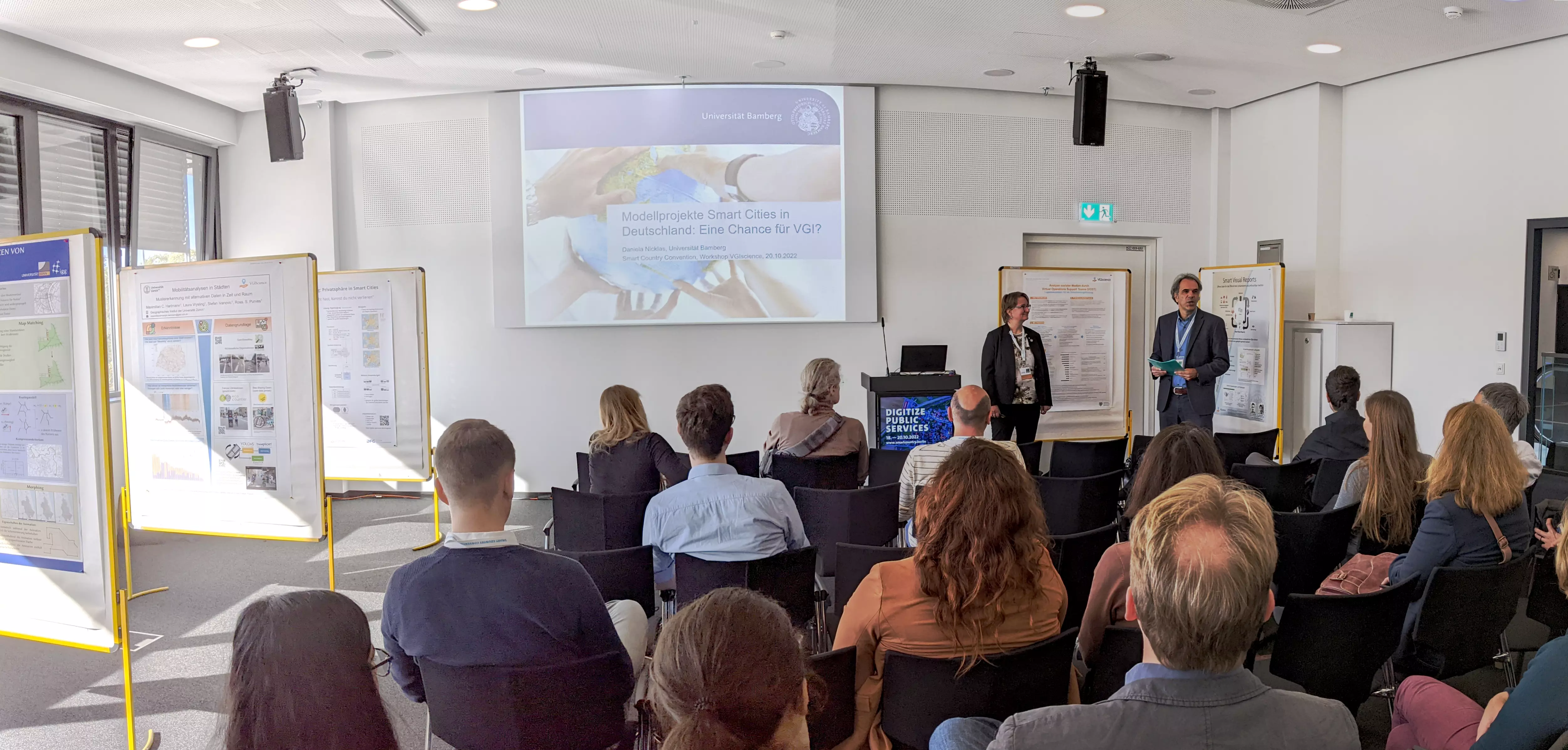
Die Verfügbarkeit von raumbezogenen, nutzergenierten Daten hat sich in den letzten Jahren rasant entwickelt, insbesondere durch Verbreitung von sozialen Netzwerken, Web 2.0 Plattformen und kostengünstigen Sensortechnologien. Der Workshop beschäftigt sich mit Ansätzen und digitalen Technologien zur Nutzung von Volunteered Geographic Information (VGI) für Smart Cities Anwendungen aus den Bereichen Umwelt, Verkehr, sowie Stadt- und Landschaftsplanung. Im Workshop wurden methodische Innovationen vorgestellt, welche im Rahmen des DFG-Schwerpunktprogrammes „VGIscience“ entwickelt wurden. Neben Kurzvorträgen gab es die Möglichkeit des direkten Austausches im Rahmen von Posterpräsentationen.
Ablauf
12:30 – 13:00 Keynote: Prof. Dr. Daniela Nicklas, Smart City Research Lab Bamberg „Modellprojekte Smart Cities in Deutschland: Eine Chance für VGI?“
13:00 – 13:15 VGIscience, Prof. Dr.-Ing. Dirk Burghardt, Sprecher DFG-Schwerpunktprogramm
13:15 – 13:30 Kurzvorstellung der Posterbeiträge
13:30 – 14:00 Individueller Austausch zwischen Wissenschaftlern und Teilnehmern am Poster
Termin / Ort
Donnerstag, 20. Oktober 2022, 12:30-14:00 Uhr
Beta 3, hub27 an der Smart Country Convention in Berlin
Poster
BirdTrace
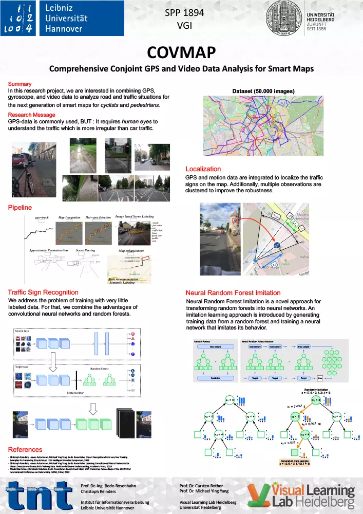
COVMAP
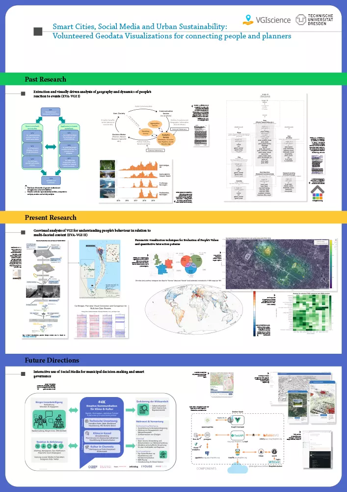
EVA-VGI
ExpoAware
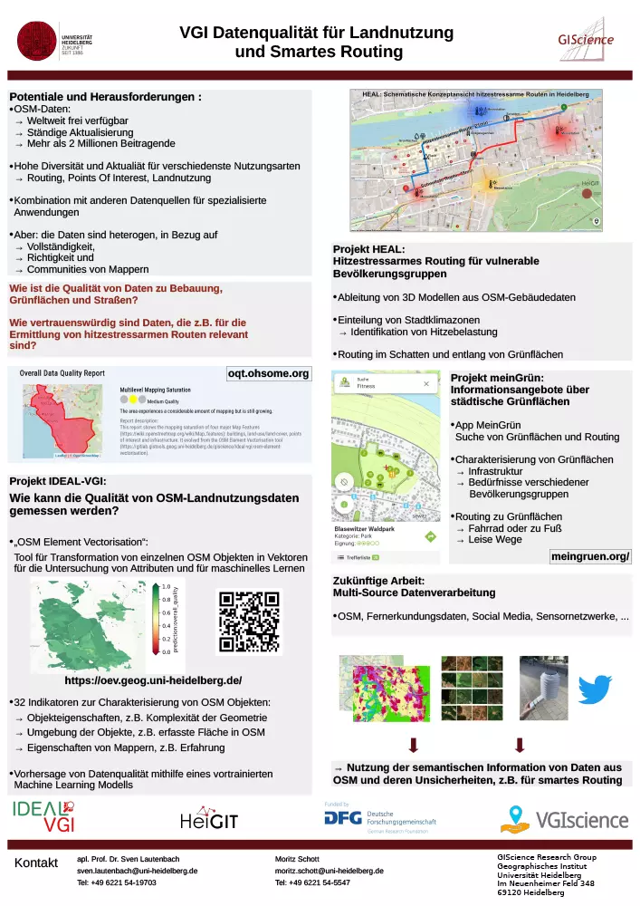
IdealVGI
Privacy
Trajectories
VGIReports
VGI-Routing
VOST
WorldKG
EVA-VGI (UZH)
SotM2022
- Su, 21.08.2022, 10:00: In their talk Comparative Integration Potential Analyses of OSM and Wikidata – the Case Study of Railway Stations, Alishiba Dsouza (University Bonn, DSIS , WoldKG Project) and Moritz Schott (Heidelberg University, GIScience, IDEAL-VGI Project) calculated dataset and community metrics to compare these two great community projects
- Su, 21.08.2022, 10:50: In the five minute lightning talk Returning the favor - Leveraging quality insights of OpenStreetMap-based land-use/land-cover multi-label modeling to the community you will learn about how OSM was used in a deep learning based approach for remote sensing image classification and how this could (and in future ‘should’, by default) benefit the OSM community. The topic is a result of the IDEAL-VGI project and a collaboration between Moritz Schott, Sven Lautenbach and Alexander Zipf from GIScience/HeiGIT at Heidelberg University and Adina Zell and Begüm Demir from RSiM research group at TU Berlin.
FOSS4G
- Th, 25.08.2022, 14:15: The new tool OSM Element Vectorisation that enables users to calculate a large set of quality indicators for single OSM elements is presented. The tool is an outcome of the IDEAL-VGI project. In an example study it was used to uncover some interesting tendencies in OSMs land-use data.
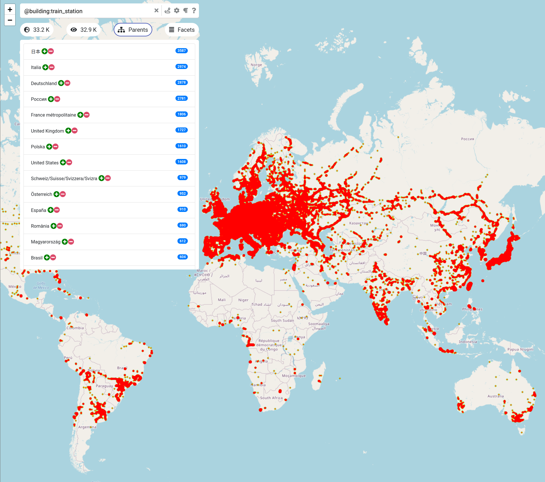
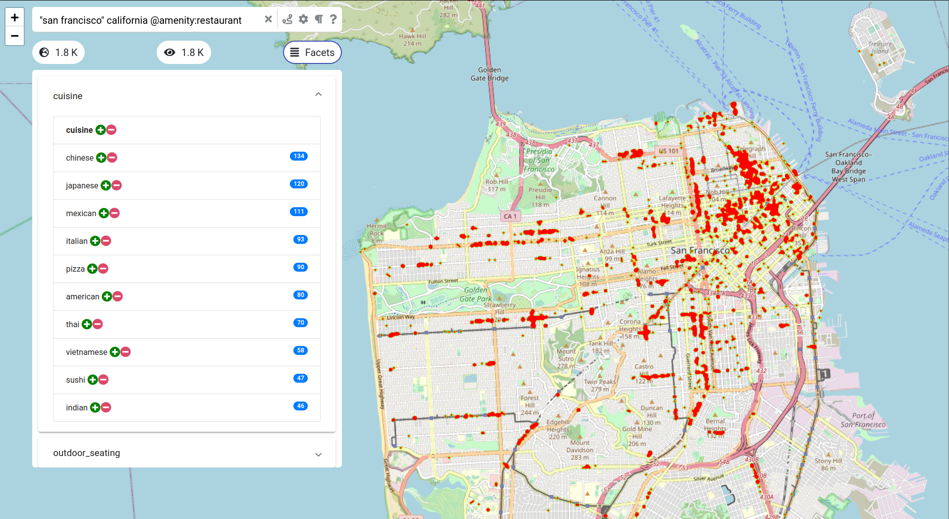
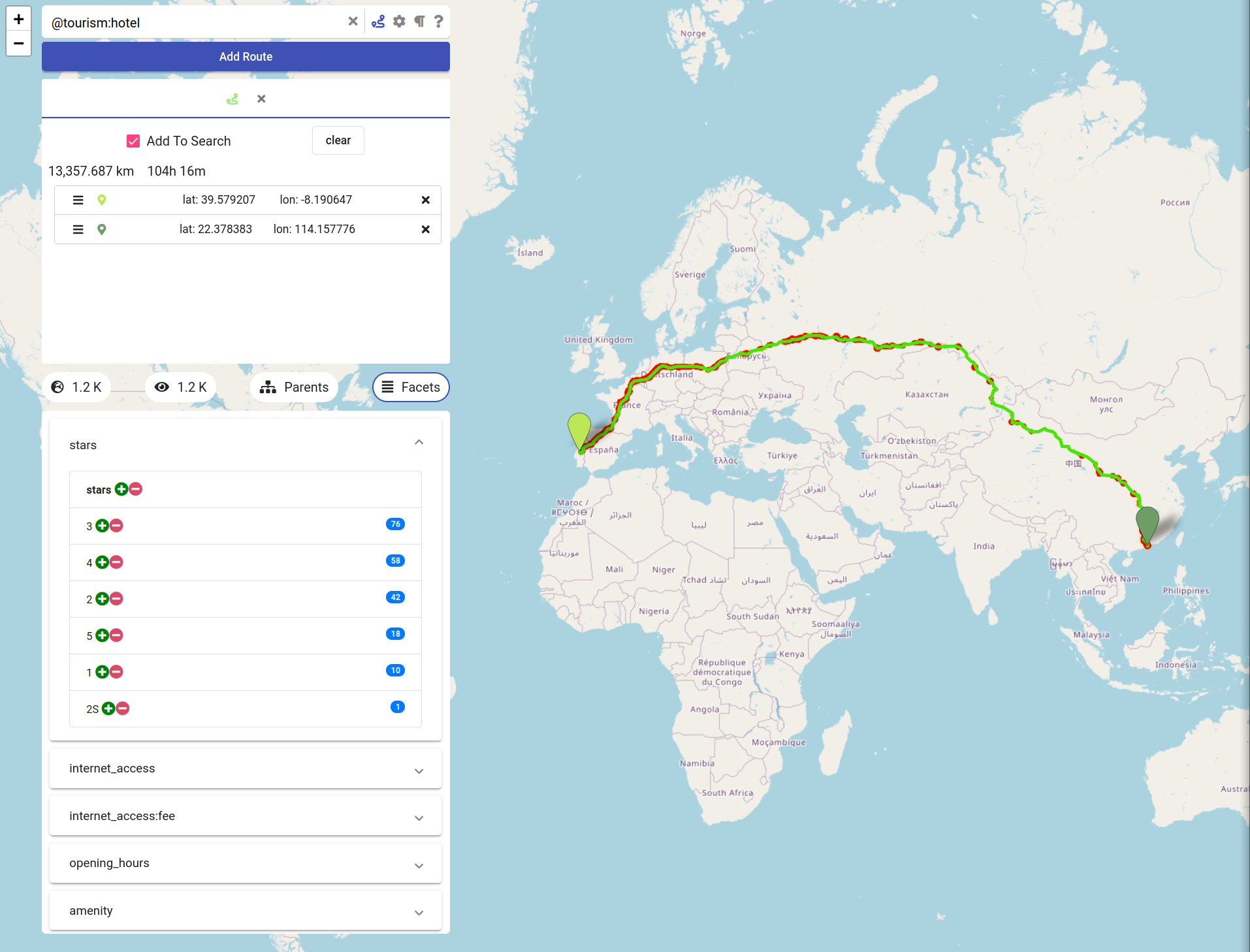
There are many challenges when dealing with such a non-tiny data set. For example, computing the optimal route in a road network with a size of several hundred millions of road segments immediately excludes standard algorithms like Dijkstra which would require several minutes of computation for a single query. Furthermore, efficiently querying and retrieving data from this data set is quite different from querying a small company employee database. Asking for all bank branches world-wide not only poses a challenge when determining the actual result of such a query, but also in terms of an efficient and comprehensible representation and visualization of the result set.
The Trajectories project funded during the the two phases of the SPP has developed algorithmic techniques and tools that allow for the efficient processing of trajectory data in the context of the OpenStreetMap project, which itself is partially created from trajectory data (the road network). As part of these research efforts in the SPP, the search engine OSCAR has been developed which allows for non-trivial querying and routing on the complete OSM planet data set.
Figure 1, for example, shows the result of querying OSCAR for all train stations world-wide. The result is presented as a heat map visualization including statistics about the distribution over all countries. Querying our search engine for restaurants in San Francisco (CA) yields the result shown in Figure 2 with an automatic differentiation of the respective restaurants according to their cuisine. OSCAR also allows for highly efficient route planning: a trip of more than 13,000 km from Portugal to Hong Kong is computed within a fraction of a second and hotels along the route are categorized according to their star rating (Google Maps can’t do that!), see Figure 3.
We have prepared a short video hat gives an impression about the power of OSCAR, but feel free to experiment yourself with our search engine.
Figures
Dr. Eva Hauthal (EVA-VGI) will present research related to “Emojis as Contextual Indicants in Location-Based Social Media Posts”.
Martin Knura (TOVIP) will give a presentation “Using Object Detection on Social Media Images for Urban Bicycle Infrastructure Planning: A Case Study of Dresden”.
Date: 4 April 2022
Time: 5:00pm CEST | 11:00am EDT | 11:00pm CST Asia
Event registration: ijgi-3.sciforum.net
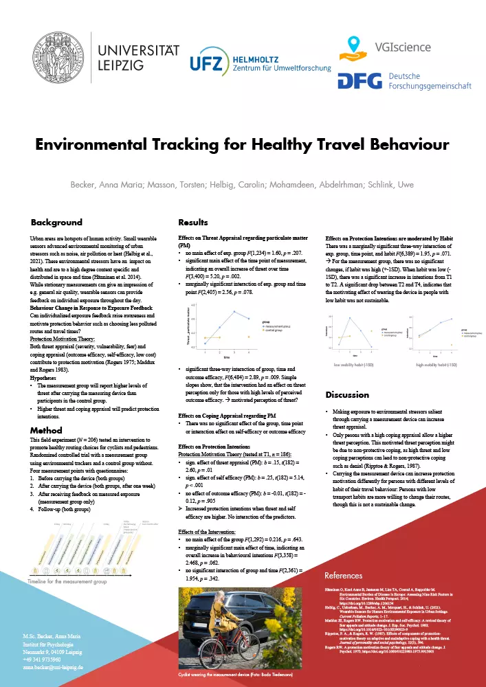
The VGIscience project ExpoAware, jointly performed by psychologists of the University of Leipzig and urban researchers of the Helmholtz Centre for Environmental Research, studies the exposure data and movement patterns and activity spaces of the participating volunteers. The attached video provides an overview of the aims and methods of this project.
As an additional subject, the researchers will now investigate the effect of feedback on the opinion, motivation, and behavior of the volunteers. Will they mitigate their exposure and avoid hot spots of pollution and heat in the future? For that purpose the volunteers are informed by feedback tailored to them, representing their personal measurements and displayed on their smartphone.
The study is further extended by an automated recommendation of less polluted routes created by an algorithm that is developed in the VGI-routing project at the University of Bonn. This cooperation is an advantage of the VGIscience research program, which is very conducive to joint research activities between specialists from different disciplines.
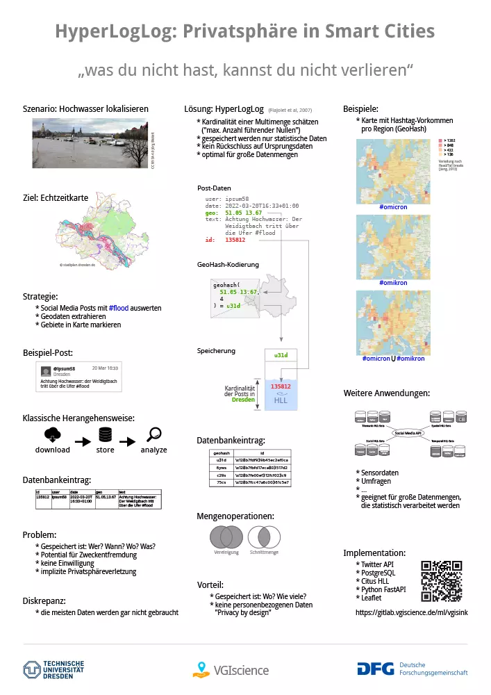
]]>Emphasizing why privacy aspects are cruicial in this field, the lecture covers research results from the entire priority programme, including the first phase. This includes publications about Abstraction Layers, HyperLogLog as a technique to store location-based social media data, extended explorations of opportunities with advanced set operations, wrapped up with a case study about a real-life use case in disaster management.
]]>